


With the vast territory and its strategic location, Indonesian waters have a large variety of UCH as the traces of human activities in the past, specifically from the spice trade period as a part of the maritime Silk Road and from World War I (Ridwan 2016; Mochtar 2016; Ardiwidjaja 2017; Polkinghorne et al. 2024). Although the Indonesian government has never published comprehensive data regarding the UCH, which is regarded as a state secret, it has been indicated that the majority of these UCHs are shipwrecks. A report from UNESCO (2014) indicated that there were approximately 3,000 shipwreck locations in Indonesian waters. Of these, the Ministry of Marine Affairs and Fisheries of Indonesia identified approximately 464 in 2011.
Data on the number of shipwrecks in Indonesia
|
No |
Region |
Total |
No |
Region |
Total |
|
1 |
Bangka Strait |
7 |
11 |
Belitung |
9 |
|
2 |
Gaspar Strait, SUMSEL |
5 |
12 |
Karimata Strait |
3 |
|
3 |
Riau |
17 |
13 |
Malaka Strait |
37 |
|
4 |
Kepulauan Seribu |
18 |
14 |
Central Jawa |
9 |
|
5 |
Karimunjawa, Jepara |
14 |
15 |
Madura Strait |
5 |
|
6 |
West Nusa Tenggara & East Nusa Tenggara |
8 |
16 |
Pelabuhan Ratu |
134 |
|
7 |
Makassar Strait |
8 |
17 |
Cilacap region |
51 |
|
8 |
Arafuru, Maluku |
57 |
18 |
Ambon, Buru |
13 |
|
9 |
Halmahera, Tidore |
16 |
19 |
Morotai |
7 |
|
10 |
Teluk Tomini, SULUT |
3 |
20 |
Irian Jaya |
32 |
|
21 |
Enggano Islands |
11 |
|||
|
Total |
464 |
||||
(Source: Directorate General of Marine Resources and Fisheries Monitoring 2011 in Ardiwidjaja, 2017)
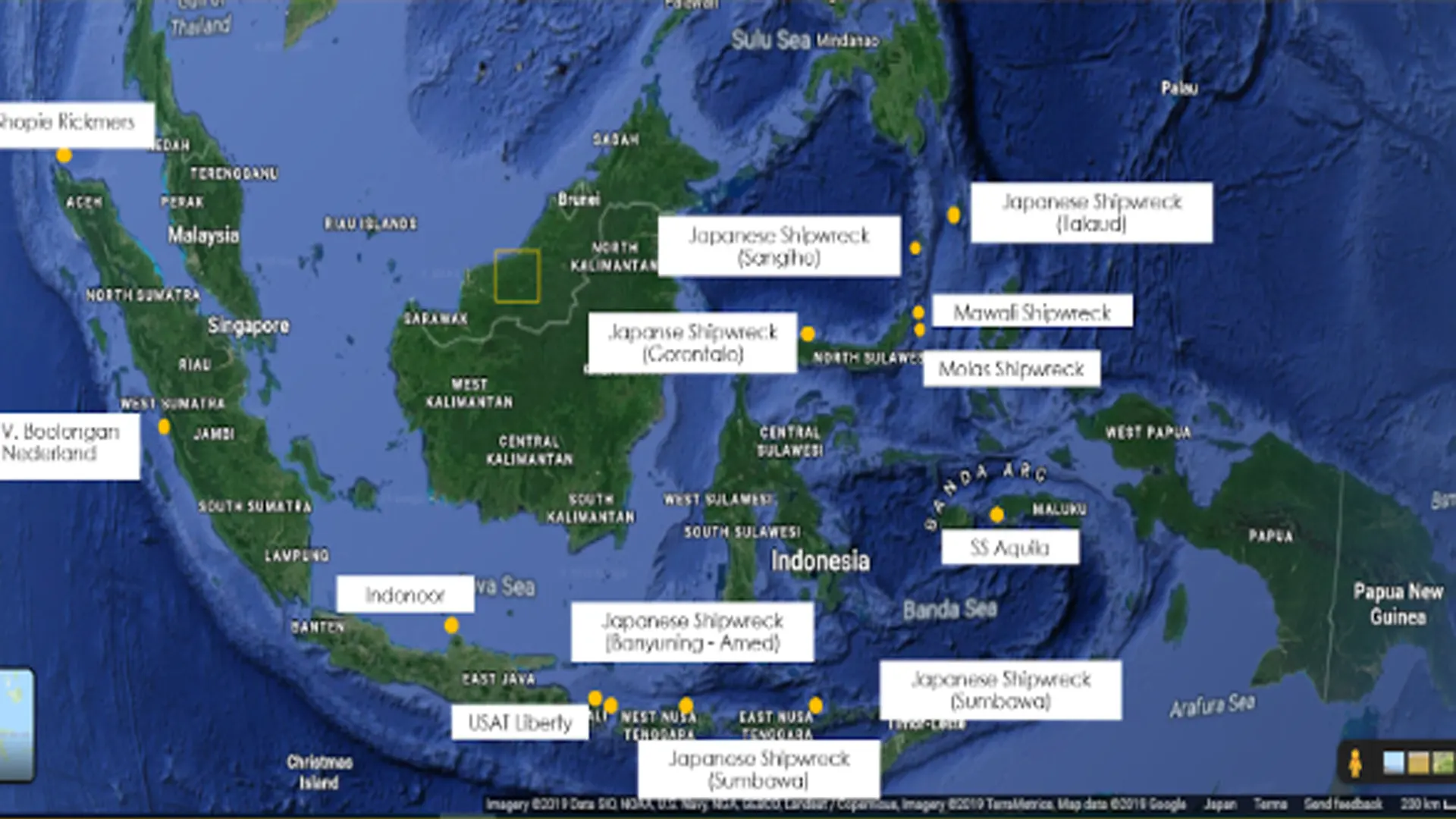
According to data from the same Ministry, the number of shipwrecks in Indonesia that have been recorded by 2022 is more than 700. However, the precise locations of only around 170 of these wrecks have been identified through surveys (Polkinghorne et al. 2024). As illustrated in Figure 3.1., Polkinghorne et al., (2024) explained that registered wrecks by the National Center of Hydrography and Oceanography of Indonesia are marked by the blue dots. Shipwrecks explored by commercial salvage companies are indicated by the light green dots and warship wrecks are indicated by the yellow dots. Shipwreck sites surveyed by the Ministry of Education and Culture are indicated by dark green dots. The others are shipwreck sites reported by fishers; these are represented by the red dots. The number of shipwrecks indeed continues to grow, considering the latest discoveries during underwater archaeological research in the last ten years resulting in several newly identified vessels. Some of these recently detected shipwrecks have not been recorded yet in the table, they are shipwrecks in Weh Island, Teluk Mandeh, Mentawai, Sangihe, and Talaud (Ridwan, 2019).
List of wreck diving sites in Indonesia
|
Name of shipwreck |
Location |
Size (m) |
Depth (m) |
|
Japanese shipwreck |
Purwakerti Village, Karangasem, Bali |
Length: 20 Width: 5 Height: 2.14 |
6 – 12 |
|
Japanese shipwreck |
Penyaring, Moyo Utara, Sumbawa Regency, Nusa Tenggara Barat |
Not available |
20 – 25 |
|
Japanese shipwreck |
Teluk Tahuna, Tahuna City, Sulawesi Utara |
Length: 40 Width: 5 Height: 7 |
18 – 25 |
|
Japanese shipwreck |
Leato Village, Gorantalo City, Gorontalo |
Length: 50 Width: 10 – 12 Height: 8 |
25- 50 |
|
Japanese shipwreck |
Melonguane Bay, Mala Village, Kabupaten Kepulauan Talaud |
Length: 160 Width: 16 Height: |
7 – 24 |
|
Japanese Shipwreck |
Waigete Village, Sikka Regency, Nusa Tenggara Timur |
Length: 62 Width: 10 Height: |
12 – 34 |
|
Molas Wreck |
Bunaken, Manado, Sulawesi Utara |
Not available |
22 - 41 |
|
Shopie Rickmers |
Teluk Sabang, Weh, Aceh |
Length: 134 Width: 10 Height: |
37 – 60 |
|
Indonoor shipwreck |
Karimunjawa, Jawa Tengah |
Not Available |
7 – 16 |
|
USAT Liberty |
Tulamben, Karangasem, Bali |
Length: 135 Width: 17 Height: |
7 – 30 |
|
MV. Boelongan Netherland |
Mandeh Village, Tarusan, Sumatera Barat |
Length: 73 m Width: 11 m Height: 7 m |
18 – 28 |
|
Mawali Shipwreck |
Lembeh Bay, Bitung, Sulawesi Utara |
Lenght: 60 m |
18 – 32 |
|
Shinwa Maru |
Monokwari, Papua Barat |
Length: 120 m |
16 – 34 |
|
SS Aquila |
Teluk Ambon, Ambo, Maluku |
Length: 100 m Width: 23 m Height: 7.7 m |
15 – 40 |